Table of Contents: Map of Ancient Israel (Jerusalem City Map)
- Palestina Antiqua – 18th/19th Century Map of Ancient Israel
- Map of Modern Jerusalem – Sunday School Union (c. late 19th/early 20th Century)
- Ludaeae seu terrae israelis tabula geographica – Tilemann Stella Sigenensis (1570)
- 1884 map of Jerusalem by Turkish cartographer (Ahmed-i Enveri, 1884)
- Madaba Map – 6th Century AD (Byzantine)
- De heylige en wytvermaerde stadt Ierusalem, eerst genaemt Salem – Nicolaes Visscher (c. mid-17th Century)
This collection traces the evolving visual history of Jerusalem and ancient Palestine through six distinct maps, spanning nearly fifteen centuries. Beginning with the 6th-century Madaba Map, a Byzantine mosaic and the earliest surviving depiction, we witness a theological and geographically significant landscape as understood in early Christianity. The 16th-century map by Tilemann Stella, within Ortelius’s atlas, presents a Renaissance European view, integrating biblical narratives with contemporary cartography, its eastward orientation reflecting different worldviews.
Moving forward, Nicolaes Visscher’s 17th-century map offers a detailed look at Jerusalem during the Dutch Golden Age. The 18th or 19th-century “Palestina Antiqua” exemplifies growing European scholarly engagement with classical and biblical geography. Ahmed-i Enveri’s 1884 Ottoman map captures Jerusalem before modern expansion, offering a unique cultural perspective. Finally, a late 19th/early 20th-century map of “Modern Jerusalem,” designed for education, showcases the city’s contemporary divisions. Together, these maps illustrate the progression of cartographic techniques, accuracy, and the diverse historical, cultural, and religious lenses through which the Holy Land has been visualized.
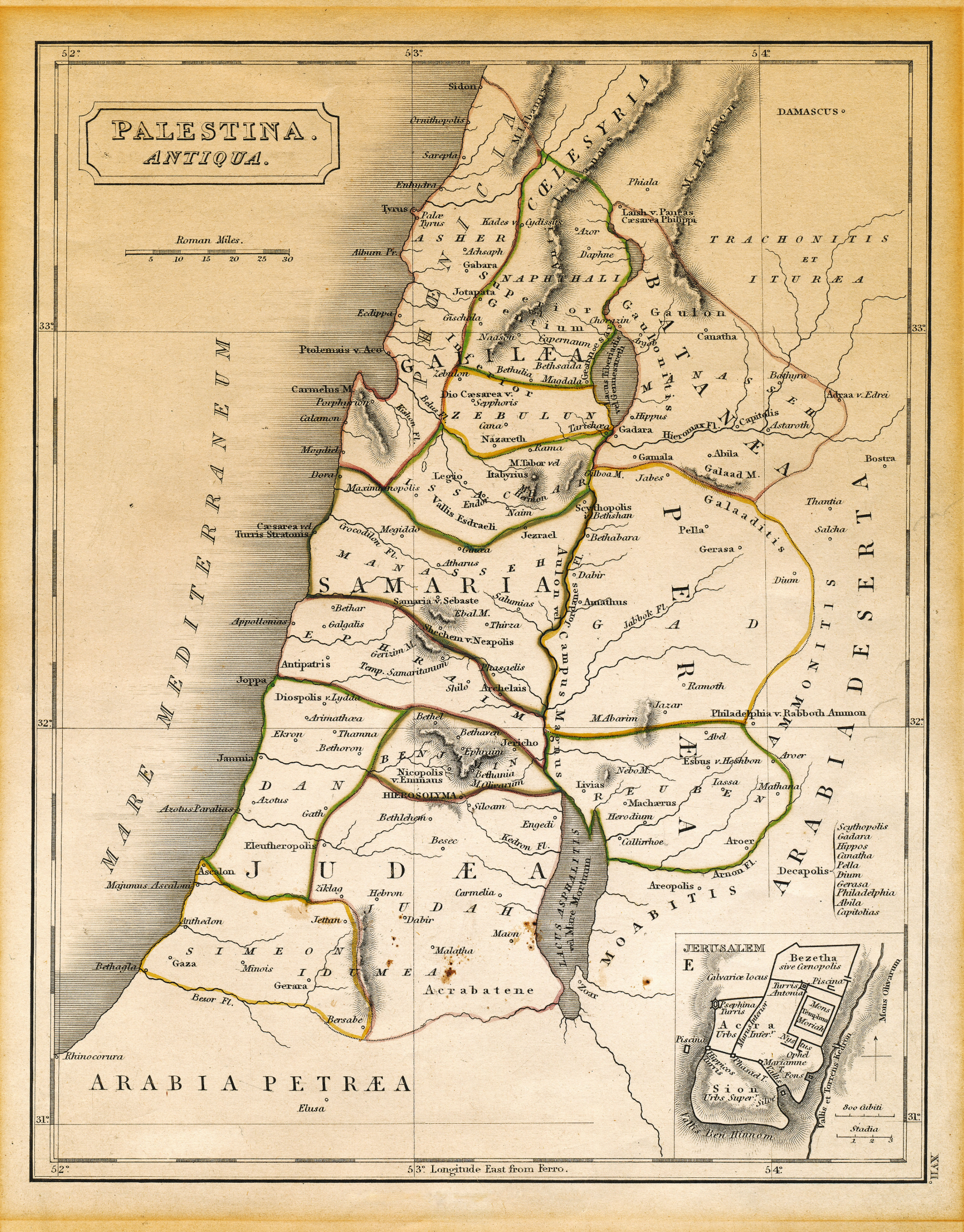
 Palestina Antiqua – 18th/19th Century Map of Ancient Israel

| * | Title: Palestina Antiqua |
| * | Likely Creation Era: 18th or 19th Century |
| * | Origin: Likely European cartographic tradition |
| * | Language: Latin (for place names and labels) |
| * | Regions Depicted: Palestine, including Galilee, Samaria, Judea, Perea, Decapolis |
| * | Key Cities Shown: Jerusalem, Jericho, Damascus (Latin script) |
| * | Topographical Features: Mediterranean Sea (West), Arabian Desert (East), Jordan River, Dead Sea, mountains |
| * | Cartographic Elements: Scale bar (Roman miles), compass rose/directional indicator, possibly hachuring/shading for terrain, decorative title cartouche. |
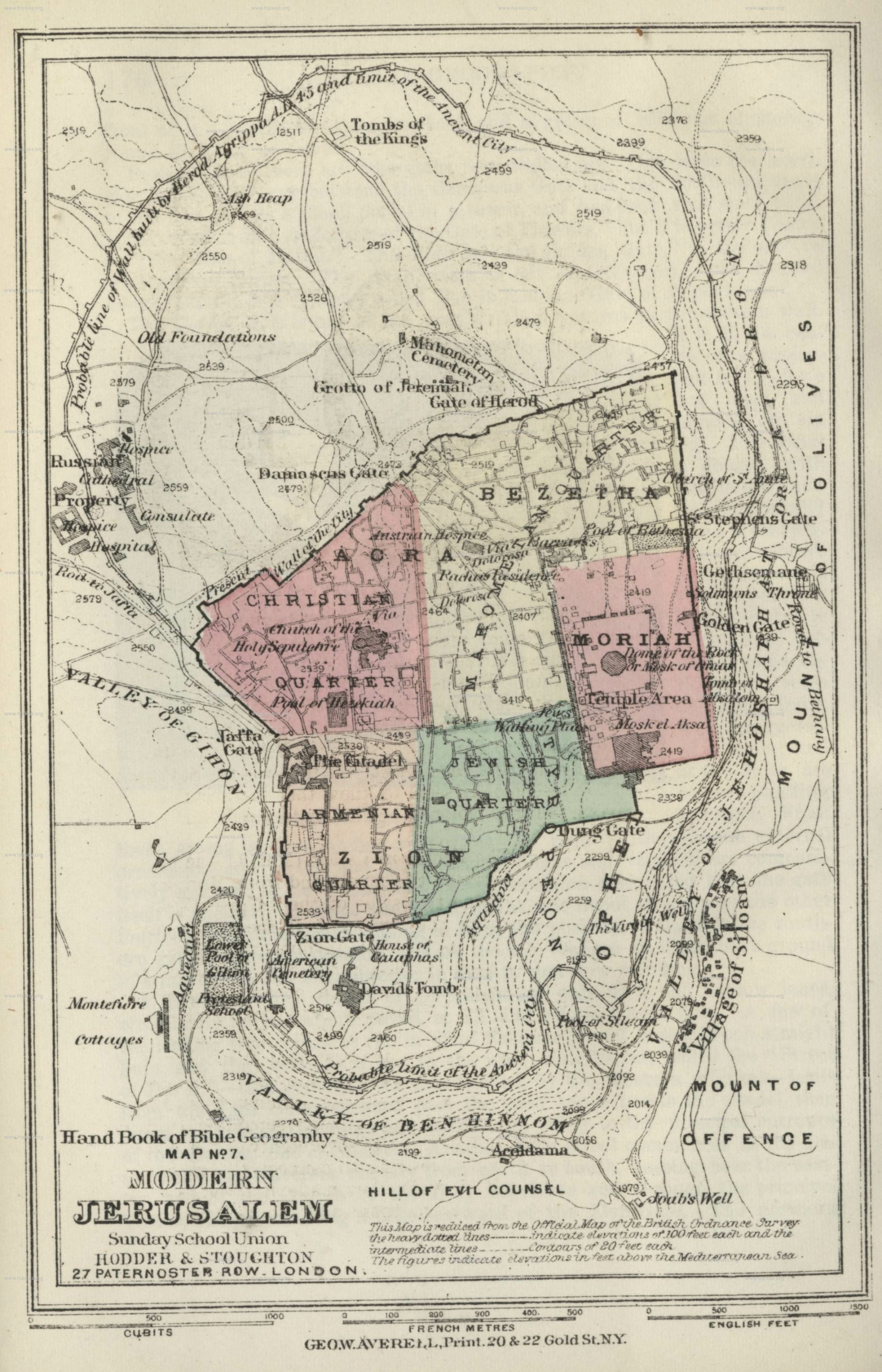
Map of Modern Jerusalem – Sunday School Union (c. late 19th/early 20th Century)

| * | Title: Map of Modern Jerusalem (from “Hand Book of Bible Geography Map no. 7”) |
| * | Publication Year: 1812 |
| * | Publisher: Sunday School Union, Hodder & Stoughton |
| * | Likely Creation Era: Late 19th or early 20th Century |
| * | Purpose: Educational (Bible Geography) |
| * | City Depicted: Modern Jerusalem |
| * | Quarters Shown: Christian, Jewish (Moriah), Armenian, “QUARTER” |
| * | Surrounding Areas: Valley of Gihon, Mount of Olives, Hill of Evil Counsel |
| * | Key Sites Marked: Tombs of the Kings, Grotto of Jeremiah |
| * | Scales: French meters, English feet |
Ludaeae seu terrae israelis tabula geographica – Tilemann Stella Sigenensis (1570)

| * | Title: Iudaeae seu terrae israelis tabula geographica |
| * | Creator: Tilemann Stella Sigenensis |
| * | Publication Year: 1570 (in Ortelius’ Theatrum Orbis Terrarum) |
| * | Language: Latin (title and text) |
| * | Region Depicted: Judea (Land of Israel/Holy Land) |
| * | Historical Context: 16th-century cartography, referencing Old and New Testaments |
| Orientation: East at the top (“SEPTENTRIO” at top, “MERIDIES” at bottom) | |
| Key Features: Locations celebrated in the Old and New Testaments | |
| Decorative Elements: Illustrations of figures and grapes (lower right) |
1884 map of Jerusalem by Turkish cartographer (Ahmed-i Enveri, 1884)

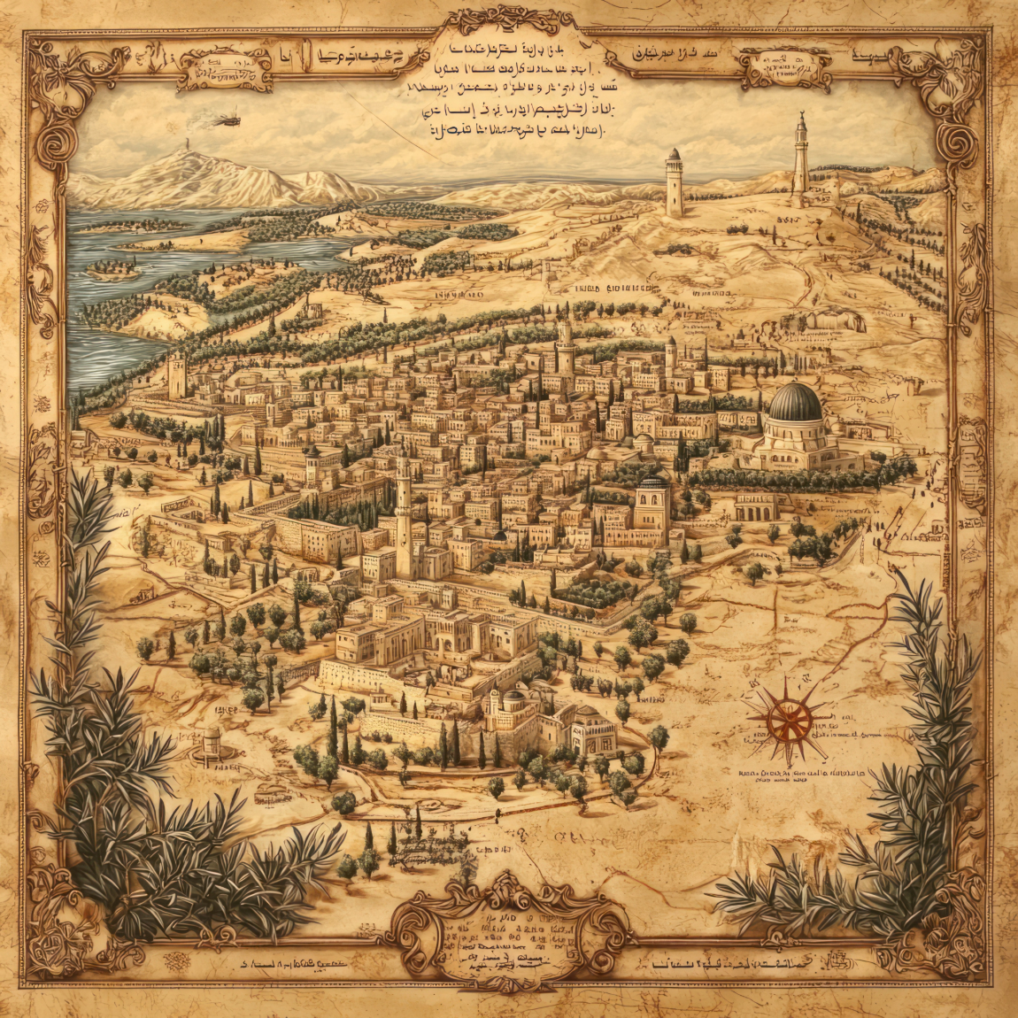
| * | Creator: Ahmed-i Enveri (Turkish cartographer) |
| * | Publication Year: 1884 |
| * | Region Depicted: Jerusalem |
| * | Historical Context: Late Ottoman period |
| * | Orientation: South at the top |
| * | Key Features: Detailed illustration of the Old City, walls, gates, Dome of the Rock |
| * | Language: Ottoman Turkish (inscriptions) |
| * | Decorative Elements: Compass, rose |
Madaba Map – 6th Century AD (Byzantine)

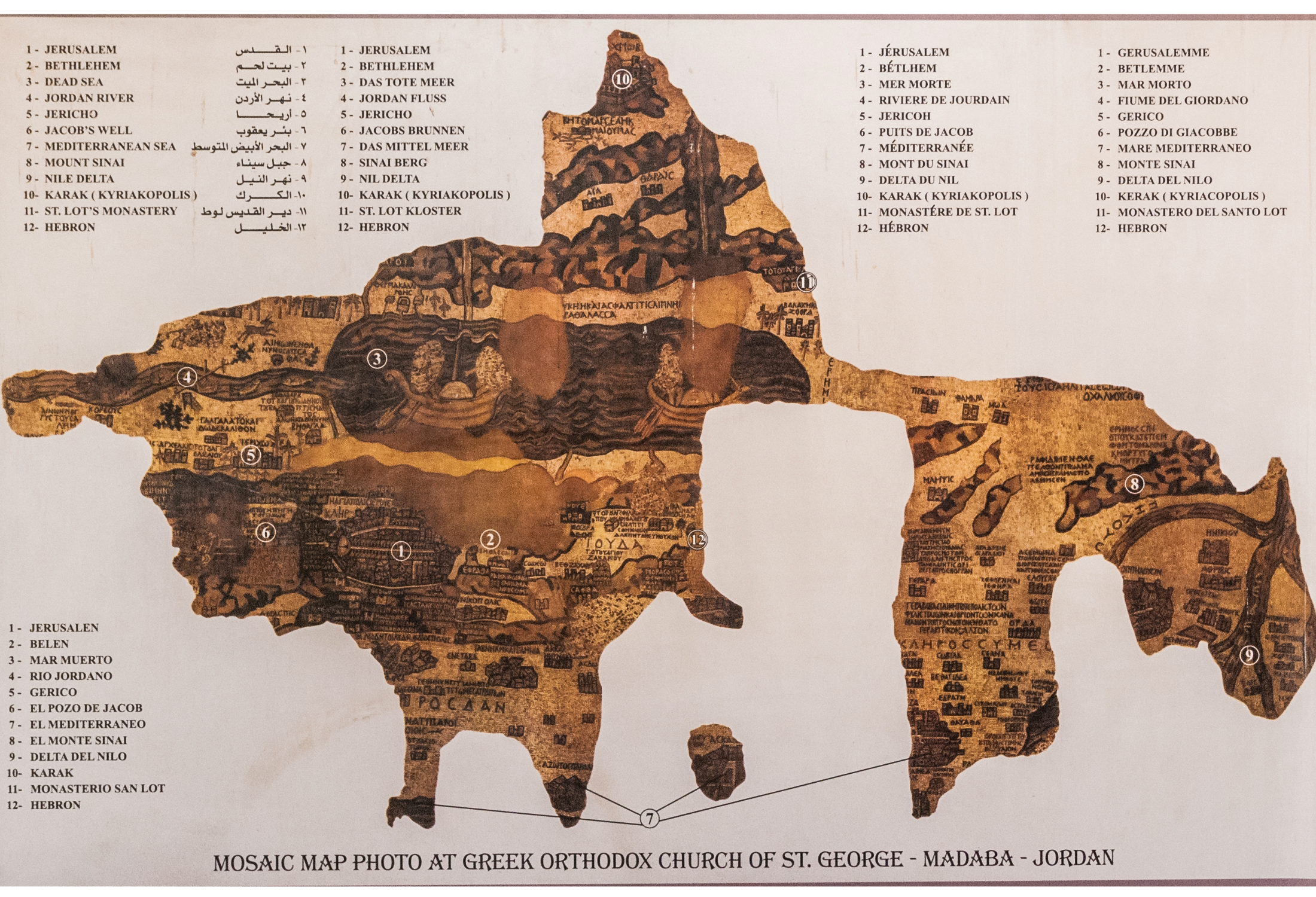
| * | Creator: Unknown artists (likely for the Christian community of Madaba) |
| * | Publication Year: 6th Century AD (Byzantine period) |
| * | Location of Creation: Madaba, Jordan (seat of a bishop) |
| * | Medium: Mosaic floor in a Byzantine church |
| * | Region Depicted: The Holy Land |
| * | Historical Significance: Oldest preserved cartographic depiction of the Holy Land |
| * | Alterations: Some figural motifs removed in the 8th century (Umayyad Caliphate) |
De heylige en wytvermaerde stadt Ierusalem, eerst genaemt Salem – Nicolaes Visscher (c. mid-17th Century)

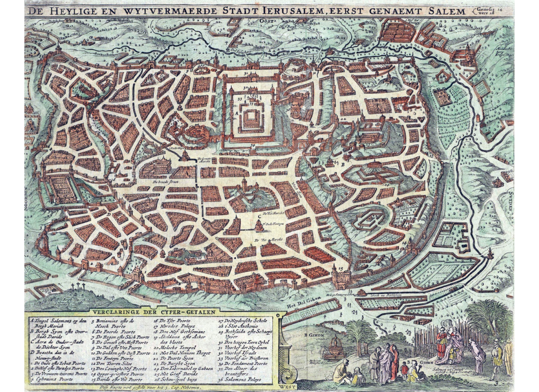
| * | Creator: Nicolaes Visscher (1618–1679) – Dutch cartographer and engraver |
| * | Likely Creation Era: Mid-17th Century |
| * | Region Depicted: Jerusalem |
| * | Key Features: Detailed city layout, landmarks, legend identifying sites |
| * | Historical Context Included (in prompt): First settlements c. 3500 BC, King David’s conquest 1000 BC, Solomon’s Temple c. 960 BC. |